D

VE INTO DATA
DIVER ENVIRONMENTAL DATA CATALOG
The DIVER Environmental Data Catalog provides access to NOAA-created data packages
for damage assessments, restoration project monitoring, publications, and
special projects. Users can download a data package for further analyses
or explore additional information. Pages for several legacy projects and
cases are available in the Projects menu.

QUERY AND DOWNLOAD DATA WITH DIVER EXPLORER
The DIVER Explorer application provides the ability to search, filter, and download a broad array of environmental data by geographic regions. For a more detailed data discovery, click on the Explorer region to start your exploration. The help materials provide guidance and examples of how to use the DIVER Explorer query tool. The data overview page describes the organization of the data, including a data specification, field definitions and valid values.
DOWNLOAD LARGE DATASETS WITH ERDDAP
NOAA’s ERDDAP is a data service that provides users a simple,
consistent way to download subsets of DIVER datasets in common file formats.
ERDDAP queries are very flexible and may be optimized for users seeking
large data downloads or specific queries from a known dataset.

VISUALIZE SPATIAL DATA IN ERMA
SELECT A REGION
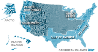
The Environmental Response Management Application (ERMA) is an online geographic information system (GIS) and visualization tool that allows users to view response, assessment, and restoration mapping layers in context with other environmental information.