Go Directly To These Datasets

Deepwater Horizon Restoration Projects
The restoration projects associated with the Deepwater Horizon oil spill focused restoring natural resources in the Gulf of Mexico. These data provide information on locations, project status, and monitoring activities.
More information...

Deepwater Horizon Natural Resource Damage Assessment Data
The NOAA repository for environmental data related to the Deepwater Horizon Natural Resource Damage Assessment.
More information...

Deepwater Horizon Restoration Monitoring Data
NOAA has standardized and integrated restoration monitoring data from Trustees and restoration projects across the Gulf of Mexico
More information...

Hudson River
Explore over forty years of compiled and standardized sediment and tissue chemistry data from the Hudson River and tributaries, including long-term monitoring of PCBs in fish, birds and mammals.
More information...

Refugio Beach Oil Spill
Information from the Response and Assessment of the Refugio Beach Oil Spill off the coast of Santa Barbara can be viewed in context with ERMA.
More information...
EXPLORE AVAILABLE DATA
Data Integration Visualization Exploration and Reporting (DIVER) Explorer allows users to search and download a broad array of environmental characterization and project planning data specific to geographic regions or activities.
The DIVER application provides unprecedented public access to a vast amount of integrated environmental data and restoration projects. DIVER is a terrific example of the advanced big data tools and initiatives that NOAA is advancing to protect and restore the environment after disasters.
VIEW MAPS IN ERMA
The Environmental Response Management Application (ERMA) is an online geographic information system (GIS) and visualization tool that allows you to view response, assessment, and restoration mapping layers in context with other environmental information.
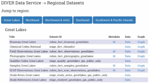
DIVER Data Services
For data services, DIVER uses ERDDAP, an open source program that gives users a simple, consistent way to download subsets of DIVER datasets in common file formats, as well as create figures and maps of data.